

How Arthur's Seat got its name: Exploring prehistoric Edinburgh
A guide to the overlooked landmarks and forgotten stories of the ancient city
The famed split in Edinburgh’s personality between medieval Old Town and Enlightenment-era New Town understandably overshadows the remnants of more ancient times in the public consciousness.
Intangible tales from our reckoning with Rome to the naming of Arthur’s Seat might capture the imagination, but they struggle to hold our attention against so many places one can still walk through and vividly experience. Yet this city’s old bones have not entirely been buried beneath later layers, writes David C Weinczock.
People have lived here for as long as it has been possible to do so. A Mesolithic camp discovered at Cramond from 8,500BC is one of Scotland’s oldest archaeological sites, dating from just after the last glaciers retreated. In the millennia to follow their descendants laid their dead in chambered cairns, raised standing stones, and fortified hilltops with ramparts and timber halls that rang out with songs in lost tongues.
Many longtime Edinburgh residents think you must journey far outwith the city to encounter such ancient monuments. True, much of what once was is now lost to the plough and pickaxe. Luckily, there are survivors. Here are some of the best of them.
Huly Hill, Newbridge
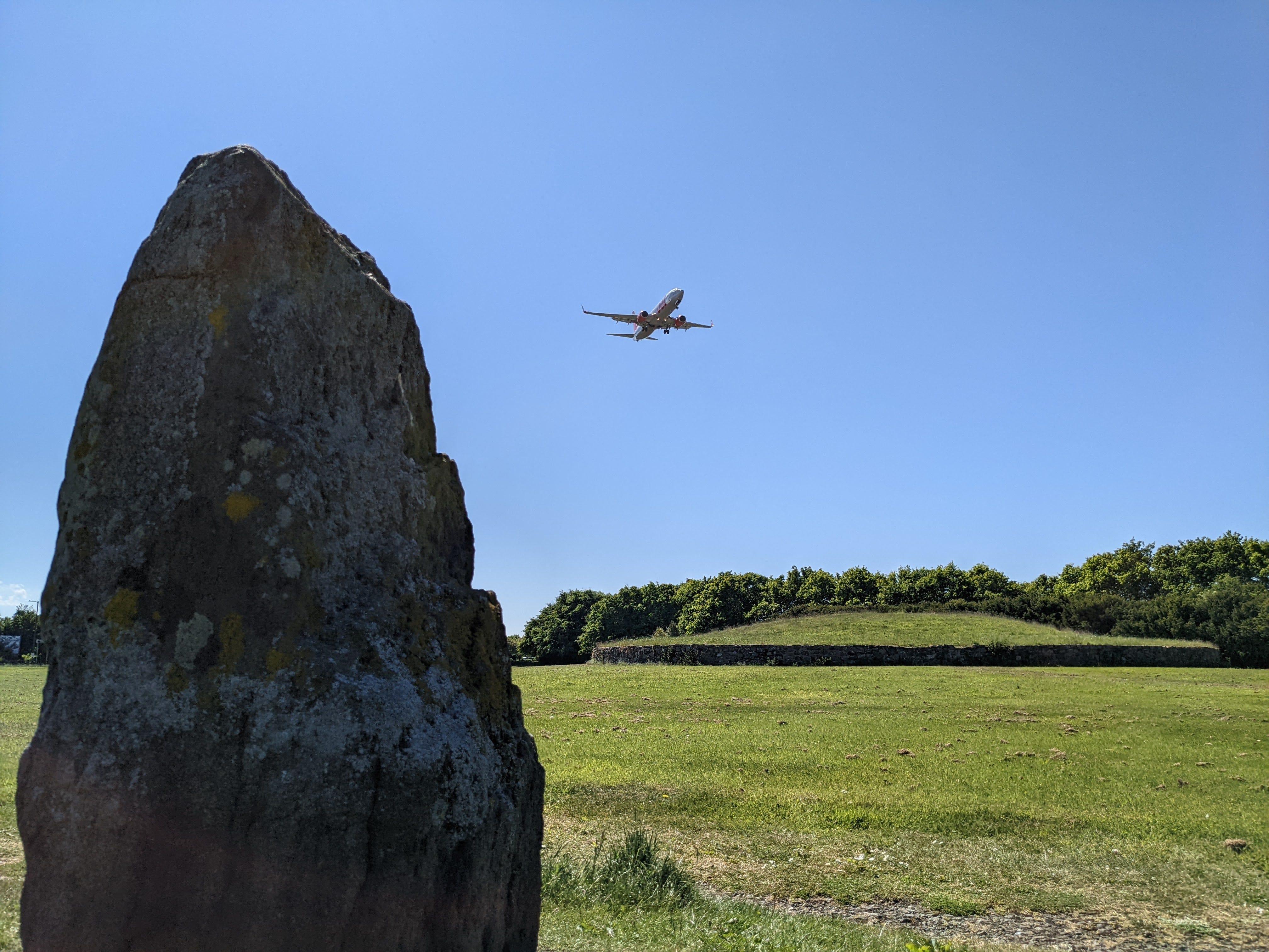
There aren’t many places in the world where you can sit in a McDonald’s or fill up on petrol while looking upon a 4,000 year-old tomb, but Huly Hill is one of them. Located alongside the Newbridge roundabout, this chambered cairn sits in a little circle of tranquillity within a sea of whirring modernity.
This type of cairn was an interment place for a high-status local in the Early Bronze Age. Three standing stones of moderate height surround it, with a fourth outside an office building across the M9. A place like this would no doubt be a tourist draw if it were just about anywhere else. As it stands, it is one of the most visible yet least-visited ancient monuments in Scotland. A few dedicated souls come here to celebrate the summer and winter solstices, and I sometimes find coins and small ‘offerings’ left atop the stones.
While the cairn has yielded no treasures, the ground around it has. A Roman road once ran right past it and several Iron Age cist burials were nearby. Most significantly, an Iron Age chariot was unearthed during the construction of the adjacent industrial estate. It is the oldest chariot burial yet discovered in Britain. A reconstruction can be seen in the National Museum of Scotland.
My favourite thing about visiting Huly Hill is that it sits directly beneath Edinburgh Airport’s flight path. The planes pass just a few hundred feet above the cairn, their powerful engines setting its packed earth trembling. Lie down atop the cairn, close your eyes, and contemplate the passing of ages.
Eagle Rock, Dalmeny Estate
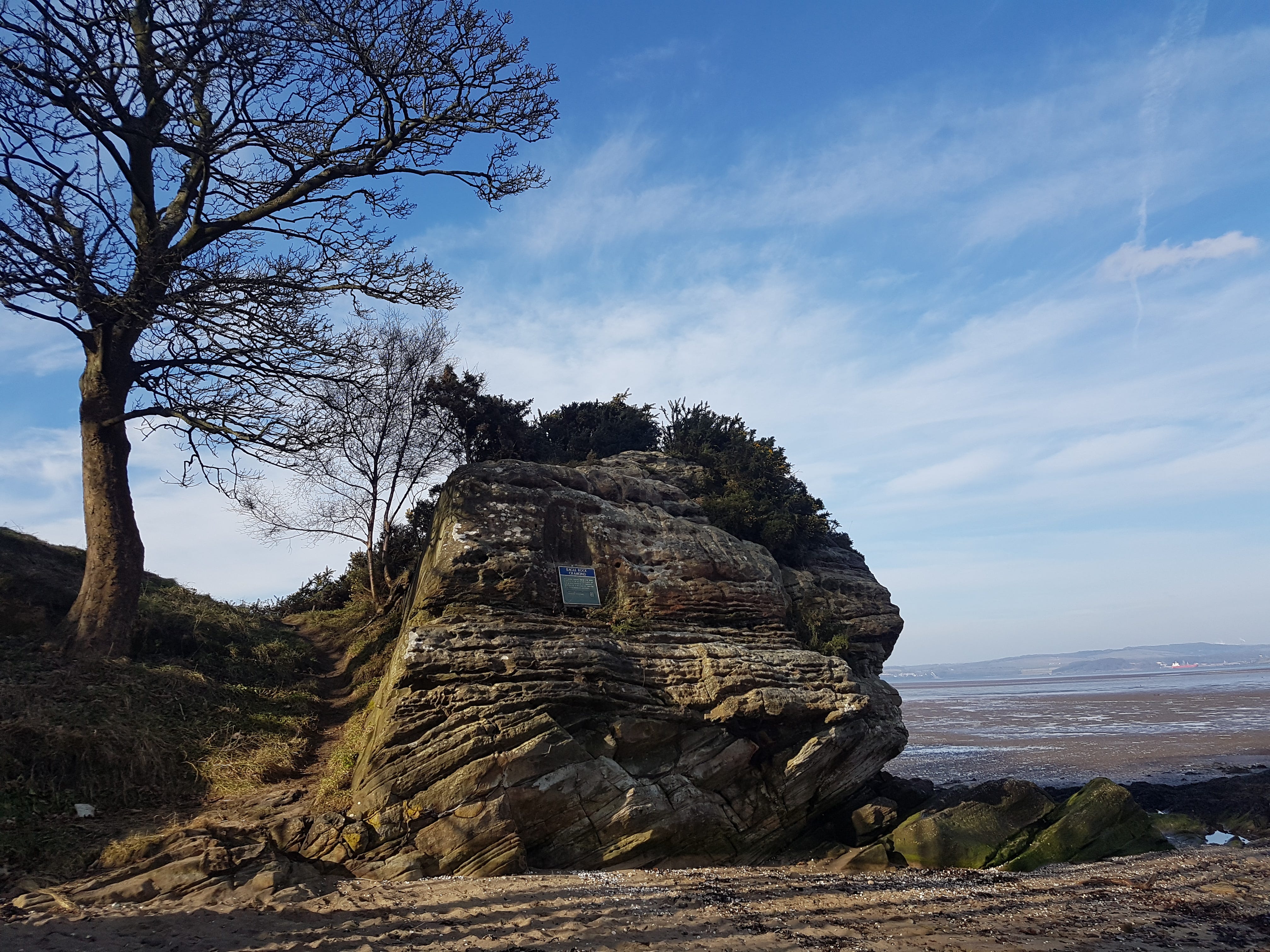
Rome launched five major invasions into Scotland between the 70s to 210s AD, building major forts at Cramond and Inveresk. These forts were vital resupply stations for the emerging ‘front line’ of the Antonine Wall. Within just seventy years of their construction, however, they were abandoned as Rome withdrew south beyond Hadrian’s Wall.
The ruins of part of Cramond fort can be found within the ground of Cramond Churchyard, and a sculpture of a monstrous lioness serving as a grave marker for a Roman officer was pulled from the River Almond in 1997. Just across the river at the high tide line is a rock outcrop where another beast is on display – no less than an eagle of Rome.
Believed to have been carved in the mid-2nd century AD, Eagle Rock was likely used as a semi-private votive offering place away from the bustle of the fort. It is one of only a handful of Roman animal carvings found in Scotland. Another, a depiction of a Pegasus, can be found inside the tight underground passageway of Crichton Souterrain, near Pathhead.
Tormain Hill rock art, Ratho
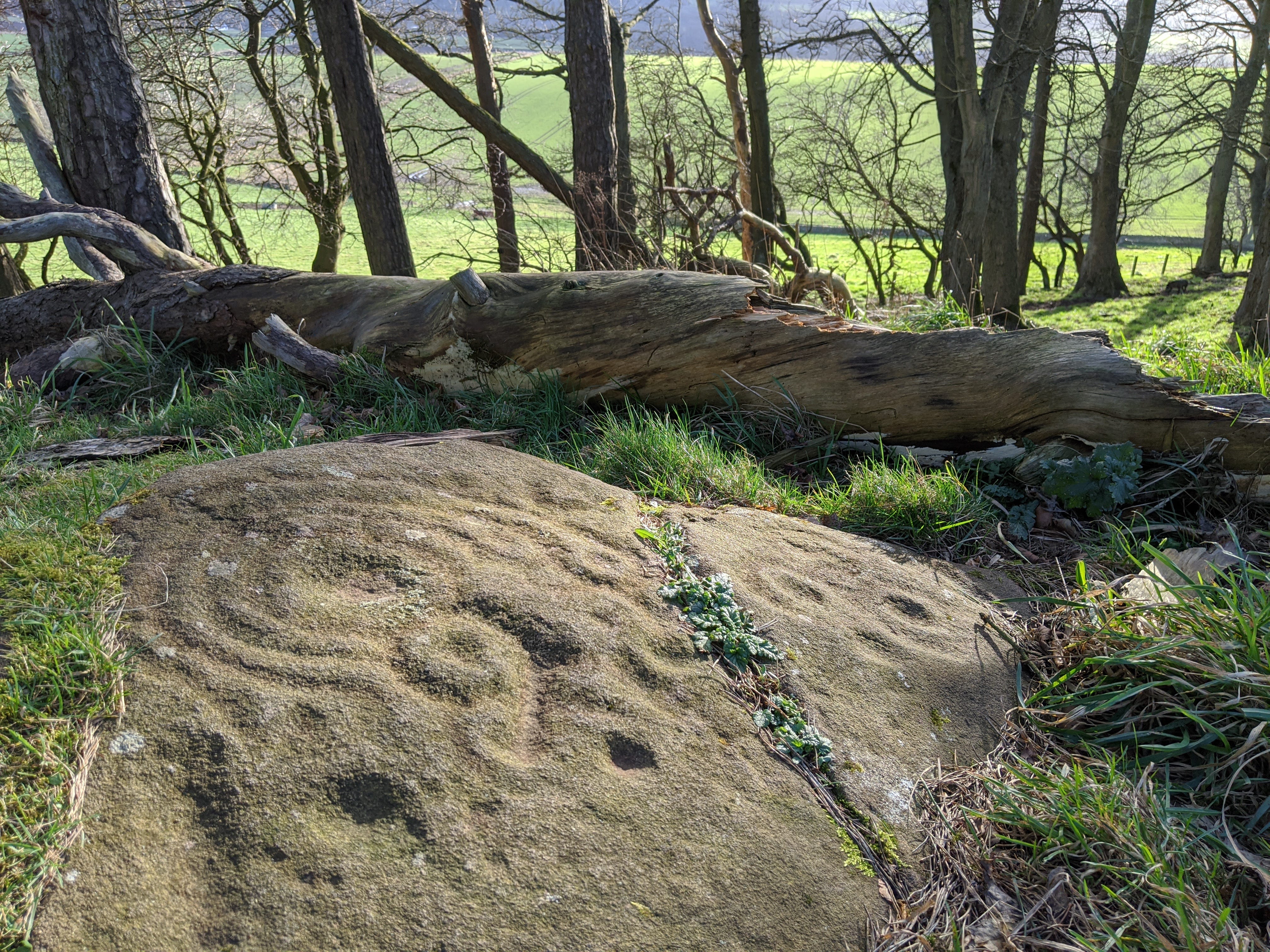
Across Scotland are rock panels and boulders adorned with strange markings – cup-like depressions, concentric rings, teardrops, horseshoe-shaped bands, and more. Carved between roughly 4,500 to 2,500 BC, no one today knows what they represent. Theories range from star maps to tribal boundary markers to depictions of the visual phenomena people get during migraines. Whatever they meant, they’re always wonderful to encounter and ponder.
Across several unassuming stones at Tormain Hill south of Ratho are some of the best examples of Neolithic rock art in southern Scotland. The surrounding landscape is replete with cup-marked rocks, Bronze and Iron Age burials, and complex earthworks, so this was clearly an important ritual landscape. Visit Tormain Hill (or any rock art site) at sunrise, sunset, or in the low sun of winter for the best visual effect.
Other cup-marked stones can be found by very diligent searchers on Corstorphine Hill and the Braid Hills. New carvings are constantly being discovered. In fact, during a walk in the Pentlands this past December I found a previously unrecorded cup-and-ring mark on the natural outcrop known as the Bore Stane. You never know, so bring a torch and take a closer look!
The Caiy Stane & Ravenswood Stone
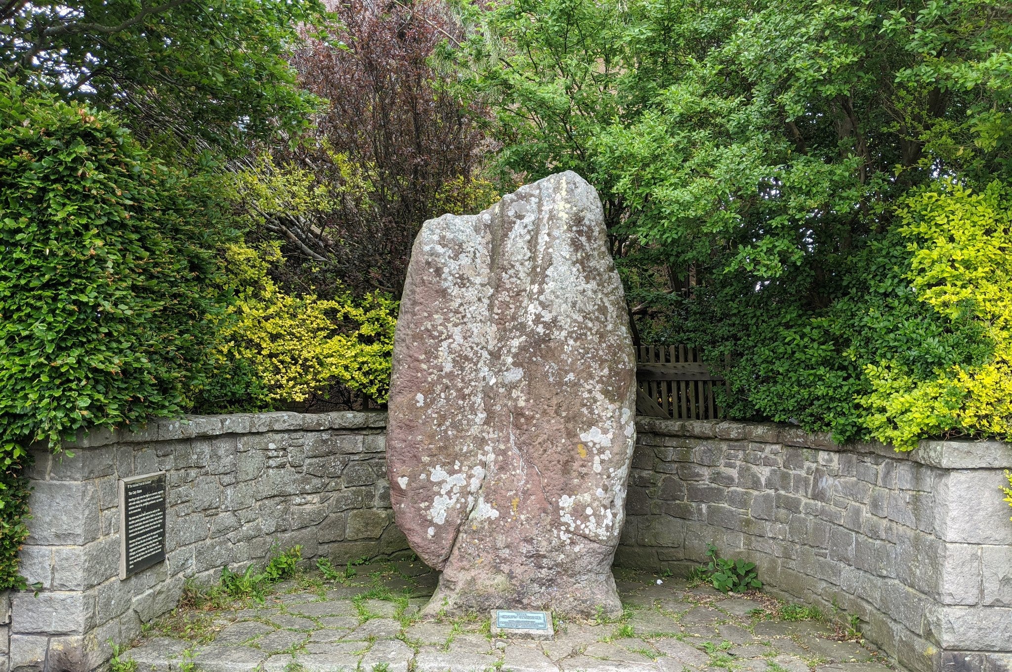
As Edinburgh sprawled southward over the past two centuries it subsumed many villages and archaeological sites. Tucked away at the unassumingly suburban junction of Oxgangs Road and Caiystane View is one of the most impressive standing stones in the Lothians, the Caiy Stane.
At over 9 feet tall it is truly giant, two-thirds the size of the largest stone at the famous Ring of Brodgar. It was raised 5,000 years ago and as recently as the mid-19th century it stood proud in open ground, with clear lines of sight to numerous ancient monuments since lost or destroyed. Carved into the side facing away from the street are numerous cup marks.
Yet another suburban standing stone can be found enclosed in a cage on Ravenswood Avenue across from Craigmillar Castle Park. At 6 feet tall it’s no slouch. Mary, Queen of Scots would almost certainly have visited it during her stays at Craigmillar Castle, and such stones were often used as mustering points for armies departing on campaigns.
Dunsapie Crag, Holyrood Park
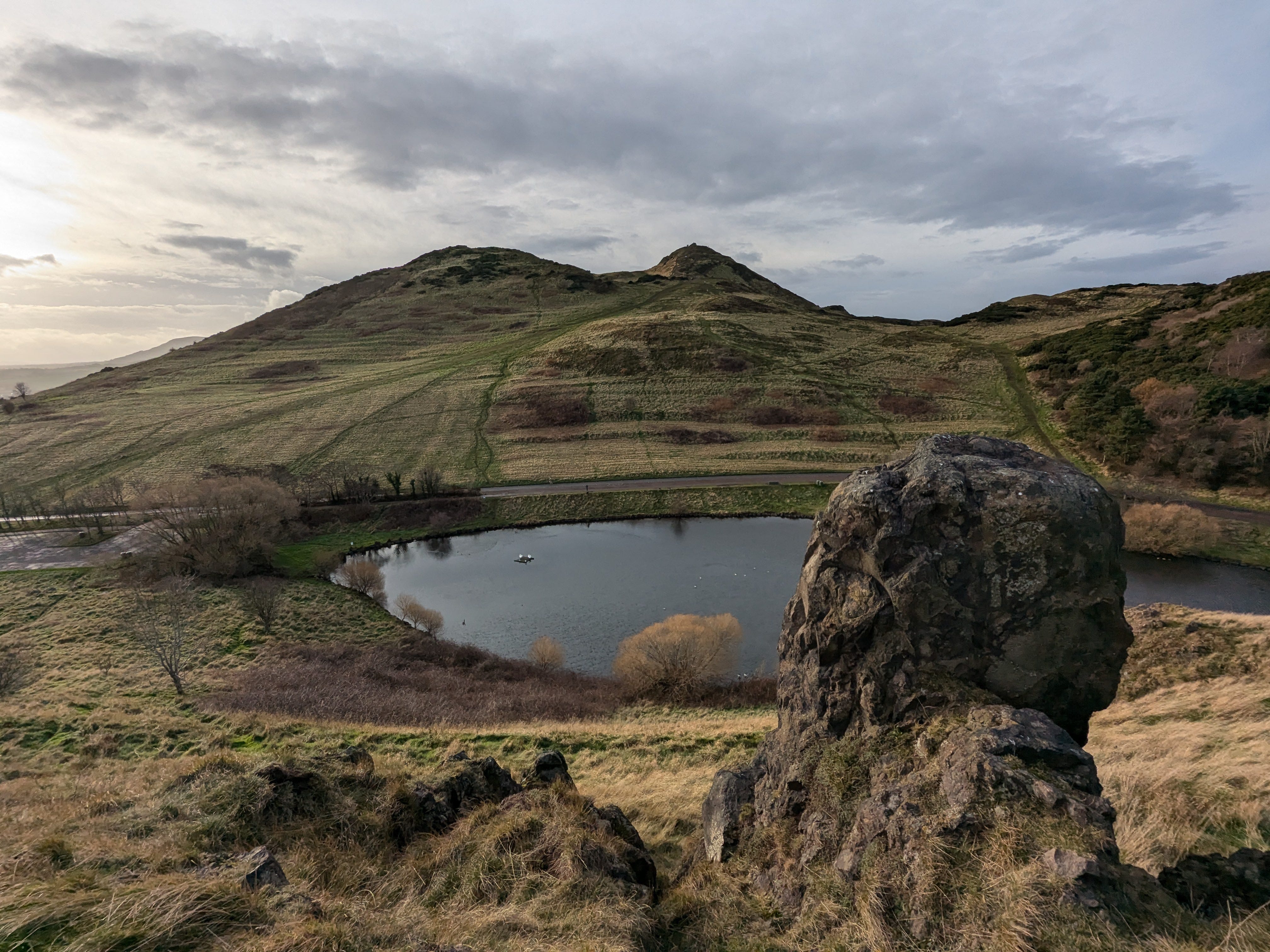
Holyrood Park was home to four hillforts occupied since the Bronze Age into the Early Historic Period: Dunsapie Crag, Crow Hill, Samson’s Ribs, and atop the Salisbury Crags. Dunsapie Crag is the best-preserved of them, though manage expectations – the timber roundhouses and ramparts which once crowned the crag are now only faint impressions in the ground. More apparent on the slope directly across from it are the forehead wrinkle-like lines of Iron Age cultivation terraces.
Hundreds of hillforts dotted southern Scotland, with dense concentrations in the Lammermuirs and Tweed Valley. The descriptor ‘hillfort’ is something of a misnomer, for they were communities first and fortresses second. Not a single Scottish hillfort, for example, withstood the might of Rome. On Dunsapie Crag there is evidence of around 25 roundhouses supporting a population of 200-300 people. Holyrood Park, not Castle Rock and its crag-and-tail where Old Town now stands, was once the heart of the local community.
The people dwelling here after Rome’s withdrawal were known as the Gododdin. Their bard, Aneirin, wrote an epic poem about their disastrous defeat by the Angles of Northumbria at the Battle of Catraeth around 600AD. This poem, Y Gododdin, contains the oldest written reference in any source to ‘Arthur’, whom Gododdin warriors aspired to be like. This is why the park’s highest peak is called Arthur’s Seat, for the legendary warrior himself is said to be slumbering beneath it.